KNOW YOUR NRD FALL 2022 NEWSLETTER

KNOW YOUR NRD FALL 2022 NEWSLETTER

The Know Your NRD Fall 2022 newsletter features many exciting updates happening at LPSNRD. Articles include Tracks to Trails, FY 2023 Budget, Making Connections, Upcoming Election, and more. Click on each button below to read the full article.

Horizontal Tabs

Looking Below the Surface
staff inspecting a sample from a drilling
Looking Below the Surface

LPSNRD’s groundwater staff is regularly gathering more information. Information that provides insights into the vital resource that impacts everyone in the district.

With the summer heat beating down, a group of geoscientists looked on as a drilling rig slowly churned into sediment and rock below, depending on the location this drilling can be 150-400 feet deep. As samples were recovered from the hole, an investigation began.

Staff from the district, the Eastern Nebraska Water Resources Assessment (ENWRA) and the University of Nebraska-Lincoln’s Conservation and Survey Division (CSD) began evaluating and documenting the subsurface samples. This information helps us gain information about the occurrence of groundwater for district residents today.

ENWRA’s coordinator, Katie Cameron noted, “Documenting and describing the nature and characteristics of the rocks and sediments below the land surface are critical steps in knowing how much groundwater is available for humans to use, and to make good decisions in managing that critical resource.”

This process was completed throughout the summer at four locations in different areas of the district. NRD and ENWRA staff select sites for drilling which will provide the most information to help evaluate groundwater resources in the NRD. Aerial Electromagnetic (AEM) data, combined with the physical drilling samples and other data sources, provide a well-rounded set of information about the area, allowing staff to identify the occurrence of groundwater resources accurately.

This joint effort provides a substantial benefit to the three partners involved. The NRD and ENWRA gain data about groundwater and geology and the CSD collects samples that can be added to the state’s geologic survey repository. Upon completion of the drilling, CSD ensures that the site is properly restored to its prior use.

Working With Landowners to Protect Resources

Erosion and runoff control can be problematic for landowners in our district. The issues can not only be frustrating to deal with, but detrimental to the land, production of crops, and to the surface water quality- effecting our lakes, streams, and wetlands.

The LPSNRD is committed to helping landowners address these issues with land treatment best management practices, such as terraces, grassed waterways, sediment basins, and more. Each year, the NRD cost-shares with approximately 250 landowners who make these improvements to reduce soil erosion. These measures slow runoff and also lead to better surface water quality downstream.

covercrops.png

Every property is unique and requires different solutions. To determine the best management practice for the land, LPSNRD technicians work in partnership with the local Natural Resources Conservation Service (NRCS) technicians to provide assistance, create designs, and project layout.

Cover crops are also becoming a more popular management practice for producers to prevent erosion in winter and spring months. A variety of plants can be used as cover crops, such as rye grass, turnip, and radish. The cover crop seed can be applied aerially prior to harvest or traditionally planted after harvest. Cover crops are also a good vegetative choice for terraces installed in the summer months. The practice is effective in reducing erosion, increasing soil organic matter, managing soil moisture, and minimizing soil compaction. The NRD has identified priority areas in the district for cover crop cost-sharing. Contact your local NRCS field office to find out if your field is eligible.

The land treatment practices, supported by NRD cost-sharing will continue to be a vital part of protecting land and water resources in the district for generations to come.

Click here to learn more.

Conservation Easements: Conserving for Future generations
blue sky and green grass
Conservation Easements: Conserving for Future generations

Native prairies, wetlands and woodlands are some of the most important natural resources we can preserve for future generations. Since 1981, landowners in Nebraska have had the ability to protect those lands through conservation easements. With the help of an entity, such as an NRD, city, or other approved entity, who are willing to hold and administer the easement in perpetuity, landowners can enter these to satisfy their desires for the property. The governing zoning authority approval is also required to finalize the conservation easement.

The LPSNRD was the first entity to enter into a conservation easement in the state. In 1982, Walt and Virginia Bagley established a 145-acre conservation easement, northeast of Lincoln, on a property known today as Prairie Pines.

Today, LPSNRD holds over three dozen conservation easements, over 2,000 acres, across the district. Each easement is maintained according to the wishes of the landowner who established the agreement, whether it be from 1982 or 2022. Even if the land is sold, the conservation easement continues.

The conservation easements in our district primarily place protection on wetlands, native prairies, hardwood forests, floodplains, or another environmental factors worth protection.

Each conservation easement held by the NRD is unique to the desires of the landowner. The perpetual conservation easements enhance property and can allow for management activities like haying, grazing, farming, forestry, and wildlife habitat. Through conservation easements the landowner retains actual ownership of the land, working with the holding entity to ensure the agreement is followed.

A recent opinion poll shows 90% of Nebraskans support conservation easements and using public dollars to fund them. The poll results transcend any political affiliation.

LPSNRD Project Updates

South Salt Creek Master Plan Project #6
Located on Salt Creek in Wilderness Park, this project will stabilize the stream bed and will protect the old Rock Island railroad bridge that will serve as a crossing for a future trail to the west by the City of Lincoln. The LPSNRD has started the process to obtain easements for the construction and future maintenance of this project. Once easements and final design is complete, the project will be out for bid and construction will be completed next spring.

Antelope Creek 40th and Scott Avenue
This project is a stream bank stabilization project, between 40th Street and Scott Avenue, to repair damage caused from the May of 2015 flood event on Antelope Creek. The LPSNRD was successful in obtaining assistance from FEMA for the design and construction of the project. The project is in the bidding process, with the anticipation of completing construction in June 2023.

Deadmans Run Project
Work continues on this $25M flood reduction project. The US Army Corps of Engineers plans to complete the design of the conveyance channel between 48th Street and Cornhusker Highway late next spring. Information on the final design will be available at that time. Design continues on the new bridges at 48th, 38th and 33rd Streets. Right-of-way needed will be finalized and acquired in 2023 and early 2024 with construction scheduled to begin later in 2024.

Tracks to Trails
Tracks to Trails

Screen Shot 2022-10-18 at 4.40.59 PM.png

LPSNRD trails stretch across our district, with three recreational trails: MoPac East, Homestead, and Oak Creek. These routes have not always been havens for cycle, foot, and equestrian traffic, but rather the corridors of railways that tied together communities.

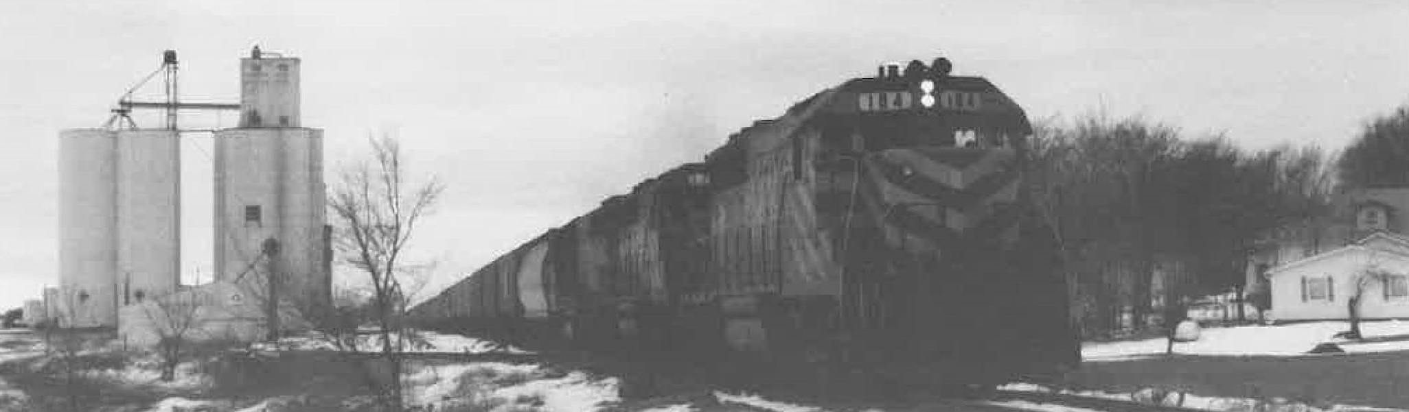
The railways date back to the 19th century. The Omaha & Republican Valley Railroad, a subsidiary of the Union Pacific Railroad began utilizing what is now the Oak Creek Trail in 1877. The Union Pacific also began servicing where the Homestead Trail is in 1880. The Missouri Pacific railway, now the MoPac East Trail, saw its first train use in 1886. Trains transported grain, limestone, lumber, livestock, coal and even travelers from town to town, vital for commerce in the region at that time.

In the 1980s, improvements to roads and changes in transportation and shipping made some rail lines less appealing. With minimal use and damage to tracks with no intent of repairing, the railroads started looking to sell the less profitable rail lines, making the corridors available for new users. With the help of the Great Plains Trails Network and Nebraska Trails Foundation, the corridors were purchased and transferred to the LPSNRD. In the case of the Oak Creek Trail, a rail bank agreement was the means for acquiring the route.

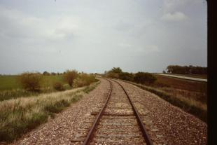
The MoPac East Trail’s first mile, east of 84th street, opened for use in 1996. Today LPSNRD’s portion of the trail begins at 98th street, the dedicated trail stretches to Wabash and includes an adjacent equestrian trail.

The Oak Creek trail also opened in 1996. An equestrian trail follows for the entire length of the trail, making it one of the state's most versatile recreational trails. 

Picture D-3.jpgPicture D-2.jpg

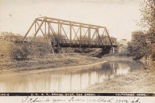
The Oak Creek Bridge in Valparaiso (1910s).           Tracks that are now the MoPac East Trail. 

Picture D-5.jpgPicture D-4.JPG

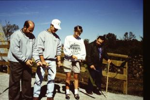
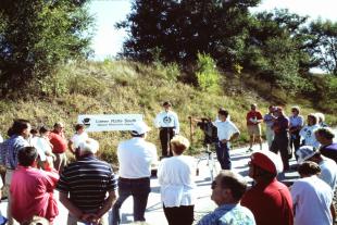
The MoPac East Trail opening ceremony (1996).      The Oak Creek Trail dedication ceremony (1996).
 

The Homestead trail opened in 2007 and extends south from the City of Lincoln’s Jamaica North Trail.

Today, the LPSNRD trails see significant use from cyclists, walkers, runners, and equestrian users. The MoPac East Trail sees hundreds of cyclists every Tuesday in the summer for the weekly Nacho Ride. The ride welcomes the public to travel along the trail from Lincoln to Eagle and back. Many riders stop to get refreshments at establishments in Eagle. The trails also hold a variety of events hosted by other organizations and groups, many of which are open to the public.

What Lies Ahead
Upkeep and maintenance of trails and the vegetation that borders the routes is an ongoing process for the district. With the help of trail users, the NRD is regularly monitoring how rainfall and use wears different areas of the trail, repairing portions as needed, and prioritizing the safety of trail users.

The district is also regularly adding enhancements and accommodations to the trail to make users’ experience even more pleasant. Recently, this has included the completion of the Wabash Trailhead on MoPac East Trail, offering parking and a vault toilet for trail users that was completed in early October.

MoPac Connector
MoPac Connector

The MoPac connector, which has the intent of connecting the trail at Wabash to the Lied Platte River Bridge Trailhead near South Bend, has garnered significant attention. Currently trail users can use an interim trail route via county roads which is marked and primarily uses 334th Street, one mile east of Wabash.

The MoPac Alliance has been discussing options with local residents, trail users, and County Commissioners to find a safe and acceptable route. The MoPac Alliance includes the Great Plains Trails Network, Nebraska Trails Foundation, Bike Walk Nebraska, and Bike Cass County. The partners and residents have been and will continue consideration of a variety of options for the prospective route. There is support to utilize existing public right-of-way.

The Nebraska State Legislature approved $8.3 million in funding for a trail connection in their most recent legislative session. In LPSNRD’s recently approved budget, the NRD has allotted $50,000 to hire an engineering firm to evaluate a proposed route.

Currently, there is no approved planned route to evaluate or to construct a new trail connector.

The district will continue to have dialogue with the MoPac Alliance and Cass County Commissioners to identify an acceptable connector trail option.

$36.7 Million Budget Approved With No Increase in Taxes

LPSNRD Board of Directors approved the FY 2023 Budget in August. The budget reduces the tax levy by 2.6% from the previous year, while maintaining the district’s programs and projects. District directors and staff began working on the budget in April and cut $3.5 million from the initial draft budget.

Board Treasurer Bob Andersen said, “Board members and staff have been very thorough throughout the budget process, ensuring the needs of the district are met. This final budget is both balanced and significant for implementing programs and projects across the district.”

Highlights of the budget include

  • Deadmans Run Flood Reduction Project ($5.9 million)
  • Antelope Creek 39th Street Repair project ($2.1 million)
  • Landowner cost-share assistance for Surface Water Quality Practices- terrace systems, buffer strips, cover crops, etc. ($1.7 million)
  • Groundwater protection, studies, monitoring, testing, mapping & best management practices ($1.2 million)
  • Stream Stability project on Lynn Creek & South Salt Creek ($1.1 million)
  • Prairie Corridor on Haines Branch Project ($1 million)
  • Stream stabilization and bridge protection along several trail corridors ($1.3 million)
  • Salt Creek Levee repairs ($900,000)
  • Community Assistance Program ($500,000)
  • Salt Creek floodplain resiliency ($300,000)
  • Flood control dam repairs and construction ($800,000)
  • Saline Wetland Partnership projects ($600,000)
  • MoPac East Trail-Lied Connector evaluation ($50,000)

23Expenditures Budget Pie.png

Click here to view the full budget. 

Planning for the Future
Deborah Eagan headshot
Planning for the Future

by LPSNRD Board Chair Deborah Eagan

Fall is in the air, and I’ve already forgotten the hot days of summer. This is great weather for outdoor activity, like biking.

The Lower Platte South District Board approved the FY 2023 Budget in August. We are aware of the financial burdens to our constituents during this time of unusual inflationary pressure. As board members we prioritize the needs of residents and communities in our District and the various programs and projects we need to provide. This year we made a special effort to lower our tax levy. While our budget has increased in total spending, our levy did not.

Still, we continue to work on many projects and programs. Notably, the District continues to commit funds to the Deadmans Run Flood Reduction Project. This multi-year project, partnered with the U.S. Army Corps of Engineers and the City of Lincoln, will reduce the 100-year floodplain benefitting 500 homes and businesses in north central Lincoln.

The district is also preparing to study, plan, and prepare for future climate challenges. Budgeted funds for the Salt Creek Levee and the Salt Creek Floodplain Resiliency Plans are just the beginning for investing in the future, preparing for future needs, and mitigating potential flooding.

As many of you know, this has been a dry year that has put a stress on farmers’ crops and has meant little to no re-charge of our groundwater. However, communities are still able to provide water to their residents with no restrictions in place thanks to timely rainfall and smart use of water by many. I want to thank you for your disciplined water use. As you know, we all share this critical resource.

2022 is winding down. It has been my honor to serve as chair. I have observed firsthand how skilled and talented directors and staff are committed to fulfill our mission. I know LPSNRD will continue programs and projects that will provide a positive impact to communities and the residents of our district for many years to come.

Election
Election

LPSNRD’s subdistricts 1, 3, and 5 will see more than one nominee for the director position on the November 8th general election ballot. Here is a complete listing of candidates by subdistrict:

Subdistrict 1
Jim Schultz, Lincoln 
Gary Hellerich, Valparaiso

Subdistrict 2
Mark Spangler, Murray

Subdistrict 3 
Melissa Baker, Lincoln 
Annette Thompson, Lincoln

Subdistrict 3 (2-year term) 
Ken Vogel, Lincoln

Subdistrict 4
Larry Ruth, Walton

Subdistrict 5
Stacie Sinclair, Lincoln
Greg Osborn, Lincoln

Subdistrict 6
Deborah Eagan, Lincoln

Subdistrict 7
Luke Peterson, Lincoln

Subdistrict 8
Tom Green, Lincoln

Subdistrict 9
Robert Andersen, Lincoln

Subdistrict 10
Susan Seacrest, Lincoln

At-Large
David Landis, Lincoln

You may be in a new subdistrict! New subdistrict boundaries were approved by the NRD, and the 2022 election is the first that will utilize these new boundaries.

Click here to view the subdistrict map. 

Other News
Other News
  • November 12-20 - The entire Oak Creek Trail will be closed during firearm deer hunting season. This annual closing is in the interest of trail user safety. Signs will be posted at all trail access points.
     
  • Cottontail WMA will be undergoing invasive tree removal as part of a Grassland Restoration Project. The project is being done to increase native grassland habitat.
     
  • November through March - Our annual sale of bare-root seedling trees and shrubs will be held, with delivery in April. Pricing, availability, and other information will be posted on LPSNRD.com and social media when the sale begins.

Congrats Mike 
After 20 plus years with the Lower Platte South NRD, Mike Mascoe, Public Information Specialist, retired in July. Mike was responsible for the district’s outreach through our website, newsletter, media releasesand, events ads, television, and radio. Mike said he looks forward to spending time with family and playing golf in retirement. All the best Mike!

MikeM.png
 

Welcome Mark
Mark Lindemann is our new District Engineer. Mark is responsible for providing engineering support for LPSNRD’s projects. He also coordinates the Deadmans Run Section 205 Flood Reduction and Salt Creek Levee improvement projects.

A Lincoln native, Mark holds a bachelor’s in environmental geology from UNL, and his master’s in geotechnical engineering from Missouri University of Science & Technology. Mark formerly worked for the Nebraska Department of Transportation managing the Geotech Department for the state. Mark likes spending time with family and kayaking, biking, and hiking. Welcome Mark!

MarkL.png
 

Making Connections
kids fishing in lake
Making Connections

This fall LPSNRD environmental education staff have been busy facilitating field trips for over 2,100 high school biology students. These trips are designed to enhance curriculum while students make discoveries that extend their classroom learning beyond textbooks. Students make connections with natural resources while hiking and dipping/netting for macroinvertebrates.

Southeast High School teacher Amanda Studebaker said, “The field trip opportunities are an amazing experience for my students. Students get hands-on experience and apply information that we are learning in the classroom. I am so excited to have my students continue to experience this amazing opportunity.” 

Each year, LPSNRD environmental education programs reach 40,000 students in our district grades kindergarten through high school. Our largest programs include field trips, classroom presentations, family nature nights and programs at each grade level that include butterfly larvae, native seeds, red worm wigglers and Earth Day kits.